


Col de Serre - Dienne

pb07
User
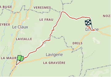

Length
12.6 km

Max alt
1607 m

Uphill gradient
356 m
Km-Effort
18.3 km

Min alt
1056 m

Downhill gradient
617 m
Boucle
No
Creation date :
2021-09-18 07:26:48.531
Updated on :
2021-09-18 13:19:27.367
5h16
Difficulty : Difficult

FREE GPS app for hiking
 SityTrail
IGN / Geographical institutes
SityTrail Plus
The world is yours!
About
Trail Walking of 12.6 km to be discovered at Auvergne-Rhône-Alpes, Cantal, Le Claux. This trail is proposed by pb07.
Positioning
Country:
France
Region :
Auvergne-Rhône-Alpes
Department/Province :
Cantal
Municipality :
Le Claux
Location:
Unknown
Start:(Dec)
Start:(UTM)
476596 ; 4997510 (31T) N.
Comments